
ORTELIUS, Abraham.
SIXTEENTH CENTURY LUXURY BRANDING


Theatrum orbis terrarum, Parergon, Nomenclator
Antwerp, Christophe Plantin, 1584£195,000.00
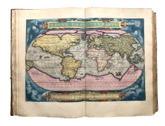
Large folio, three parts in one, separate t-p to third, Theatrum: ff (xii), 100 double-page numbered plates of one or more maps; Parergon: ff. 101-102, plates 103-114; Nomenclator: pp. 77 (ix), lacking final blank. Roman and Italic letter, woodcut floriated and historiated initials, handsome engraved allegorical first t-p with the personifications of Europe, Asia, Africa and America, title of Parergon within border with strapwork and foliage, printer’s device to second t-p, full-page portrait of author engraved by Philip Galle (1537-1612), and 112 double-page plates including 145 geographic maps (varying dimensions), all in splendid contemporary hand-colouring with extensive gold and silver details. Lighy age yellowing, browning to a few ll., light foxing to initial ll., small early repair to three ll. probably relating to early autograph or library stamp, one with three words replaced in early manuscript. Intermittent marginal soiling mainly to lower outer blank corners, light see through to blank verso of some maps. An excellent copy on thick paper, in contemporary publisher’s calf, covers double blind and single gilt ruled to a panel design, a bit rubbed, outer frame bordered with a gilt floral roll, inner with a gilt chain roll and gilt fleurons to corners, large baroque strapwork cornerpieces and centrepiece with tendrils, leaves and lions all gilt, a.e.g., exceptionally richly gauffered. Spine with double gilt raised bands and flower tools in compartments. Rebacked, extensive repairs to lower cover, outer edges and head of spine. Large engraving of the diptych of Boethius (V century, Santa Giulia Museum, Brescia) from J.C. Hagenbuch, ‘De diptycho Brixiano Boethii consulis epistola epigraphica’ (1749) to rear pastedown.
This edition contains the first Western map of China and Japan as well as the first appearance of new maps of Florida, Peru and North Eastern Mexico.
A superb deluxe copy, finely coloured and profusely highlighted in silver and gold, of the first modern world atlas, in a luxury publisher’s binding. A scholar, but primarily a publisher, Ortelius made his atlas attractive to the contemporary mannerist and baroque taste embellishing his maps with complex frames, countless ornamental illustrations and minute particulars. For this reason, the ‘Theatrum’ was the most expensive book of its day and one of the most desired. Lavishly illuminated copies were hand-coloured by the ‘afzetters’ (artists) of the prestigious school of Antwerp. Some of them were produced for presentation to important figures, but many were made on commission for wealthy clients and customised according to their specific requirements. Often, clients would send their requests for illuminated copies to Ortelius in person, who worked for many years as a decorator of maps himself. This copy is outstanding as every plate has details highlighted in gold and silver: the lettering, scales and compasses, fine borders of cartouches, sea waves, ship flags, sea creatures and the small characters’ clothes. Such pervasive and expert application of gold and silver is rare, as it was the costliest form of decoration. The only comparable example sold at auction in recent years was from the magnificent library of the bibliophile and map collector Lord Wardington (Sotheby’s, 10 Oct. 2006, 355).
Abraham Ortels, known as Ortelius (1527-1598) was a Brabantian cartographer and geographer. In 1547, he began his career as a map illuminator at Antwerp, where he also worked as a bookseller and print dealer. He travelled extensively around Europe, especially with the great cartographer and friend Mercator, and was appointed geographer to Philip II king of Spain. The ‘Theatre of the World’ (first published in 1570), is a “landmark in cartographic publication” (PMM) which marks the beginning of the golden age of Dutch cartography. Ortelius called his atlas a ‘theatre’ (Theatrum), because – rather than a simple collection of maps – it was conceived as the stage of a beautiful spectacle that takes the reader on an imaginary voyage throughout the entire known world. For this monumental project, he gathered individual maps of cartographers from all over Europe, reviewed and redrew them himself, then had them engraved by the artist Frans Hogenberg (1535–1590). For the first time, a complete picture of the globe was presented and equal attention was dedicated to every part of it, with detailed descriptions and scholarly citations. The structure of the atlas is simple: it opens with a map of the world, followed by continental maps of Europe, Asia, Africa and America, then it shows smaller regions within each continent. At the end, ‘Nomenclator Ptolemaicus’ is a long list of geographical names.
‘Theatrum’ was an immediate success, and it became so popular that – between 1570 and 1612 – over forty editions were produced in many different languages (Latin, Dutch, French, German and Spanish). This is the second Latin edition by Plantin, considerably improved and enlarged from the previous, comprising 112 double-page plates (the first edition contained 53) of which 24 are new additions. Among them, number 93 is the first map of China and Japan printed in Europe, remarkably containing Chinese characters in its description. Also new is number 8, depicting Peru, Florida and Guastecan (one of four plates dedicated to the Americas in this edition). Ortelius gives a colourful description of these regions: Peru is “the richest in gold of the entire world” and the inhabitants of Florida are “barbarians (…) they ate spiders, ants, lizards, snakes and all sorts of venomous creatures and insects”. Eight new plates were added to the ‘Parergon’ (here in its second edition), an extremely fascinating section of the atlas with historical maps illustrating the geography of Roman times. Ortelius is the only Renaissance atlas maker who mentions his sources, and the list of contributors (‘catalogum auctorum’) in this edition counts 134 names.
Ortelius’ example was followed by generations of cartographers and his maps were consulted and studied non only by geographers. The maps of Asia and Africa displayed in this edition inspired the geography of Christopher Marlowe’s great play Tamburlaine. The influence of ‘Theatrum’ was immense, ultimately shaping the accepted vision of the world.
USTC 407894; Adams O337; BM STC Netherlands 16th century, p. 162; Shirley T.ORT-1t and T.ORT-1u; Nordenskiöld II, 168; Voet 1820; PMM 91; Alden 584/51; Sabin 57697. Not in Brunet or Graesse. Cf. C. Koeman, The History of Abraham Ortelius and His Theatrum Orbis Terrarum (1964).In stock