
KOREAN MAP, Jeolla Province
JEONG CHEOK MAP OF KOREAN PROVINCE

Map of Jeolla province, Joseon Korea
Korea, first half of 18th century£2,250.00
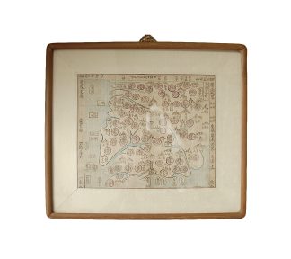
Hand-drawn map, first half of the 18th century, depicting Jeolla , sixth of the eight provinces of Joseon Korea (Joseon paldo , which were reorganised into the 13 modern provinces in 1896.) It states the administrative classification of each district or outpost, as well as how many days of overland travel are required to reach it from the capital. It was intended to aid scholar-officials holding government civil service positions in planning their journeys. This map was produced by an unknown Joseon Korean cartographer in the celebrated and highly distinctive “Jeong Cheok” style, and is a superb example of this quintessential pre-19th century cartographical tradition.<br />Mounted within thin oriental wood, framed and glazed, the map, on bamboo paper, is set within a fabric border 5.9cm deep, measuring 45cm x 39.3cm. The map itself is 33cm x 27.3cm. Text border on all sides, however the lower border has been cropped. The borders that remain are 1.4cm deep. The paper has occasional faint darker areas, however none diminish the legibility or artistry. The map was folded into twelve parts, leaving two horizontal and three vertical creases, with very slight wear. Small hole in the lower centre of the map at the intersection of two creases; tear at lower edge (6.5cm x 3cm at its worst) affecting the depiction of the southernmost peninsula.
The map has been produced in the style of Jeong Cheok ( / , 1390 – 1475), a successful 15th century cartographer, himself a scholar-retainer who served several Joseon kings. The modern concepts of latitude and longitude were not understood in Korea until the early 19th century, and the flatness and distortion of the land in Jeong Cheok-style representations reflect this. Nonetheless, the shape, layout, and topographical properties of the provinces are depicted with impressive accuracy, enabling an overland traveller to plan the most direct route avoiding natural barriers.
“Jeong Cheok” maps bear a number of distinct stylistic characteristics. First, further information is added in a text border surrounding the map. Second, natural topographical features are highly simplified; mountains are indicated symbolically as a jagged row of uniform peaks, and coasts and waterways are low-detail. Third, districts (always with two-syllable names) and military bases are represented by uniformly sized bubbles. In this map, these bubbles are pink; the district name is written down the centre of the bubble; to the right is the number of days of overland travel required to reach it from the capital, and to the left is its administrative classification. The Joseon administrative classification system includes, from largest to smallest, the bu (provincial capital city), mok (mid-level city), gun or su (county or prefecture), and finally lyeong or gam (small town).
The lines and text of the map are drawn in black ink. Land is uncoloured, while water is depicted in a light blue wash. Strikingly, water is coloured darker blue where it meets land. Mountains are coloured brown and labelled. Islands, also named, are depicted as white ovals in the ocean. There are one military base (byeongyeong ) and two naval bases (suyeong ), left and right, in pink bubbles. Land-based outposts (yeogdo ) and offshore ocean settlements are marked in white boxes. There is a title box with “Jeolla province – six” (Jeolla do lyuk ) in the top right corner. Within the text border running along the top, left, and right sides, there are remarks about what lies beyond the map in these directions.
In stock