
MING CHINESE MAP
MING CHINA’S LAND, ISLANDS, AND RIVERS

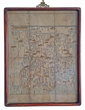
Overview of the Realm (Tianxia tu lüe )
China, 1625-1650£12,500.00
Fascinating hand-drawn map depicting Ming dynasty (1368 – 1644) China and surrounding lands produced by an unknown Chinese cartographer between 1625 and 1650. The map aids long distance journeys by water. It makes prominent the inland waterway networks and oceans of Ming China and beyond. It also depicts those locations – cities, countries, and islands – that can be accessed by navigating expanses of water, including distant locations. Other unusual features include the notation of corresponding constellations for each province and the names of local tribes. Stylistically, the map is clear and minimal, using a simple palette of red, brown, and blue wash. Overall, with its culturally rich and eclectic content and its portable size, this map would have been a valued personal possession of an enthusiastic and well-travelled scholar, learned merchant, or even Jesuit. It is highly likely that the map was unique to its original owner.
Mounted within thin oriental dark wood, framed and glazed, measuring 39cm x 30.5cm, on bamboo paper. The paper is slightly yellowed and there are occasional darker marks, however none of this diminishes the legibility or artistry. Previously folded into six parts, the creases are dark and worn, so writing and imagery is occasionally partially obscured. Small tear on character “ ” of the title. The map is bordered with a thin black line, set within a further black-lined border, 3.5cm deep at foot, 1-1.3cm at left, 0.3-0.6cm at right, and 5.3-5.5cm deep at head. The map measures 28.5cm (head) x 28.7cm (foot) x 29.7cm (left) x 29.4cm (right); it does not form a perfect square. In the top right hand corner is a box bearing the title “ ” (and the final character is a variant.) Text and lines are in black ink. Land is not coloured, water is indicated with a pale blue wash, and mountains are dark brown. Province boundaries not obvious from natural topological barriers are lined red. Ringed in red are cities of political, cultural, and historical significance. Names of the provinces are ringed in black, and of towns and cities in black boxes.
Within the map, the fourteen administrative provinces of Ming China are disproportionately expanded relative to surrounding areas. They account for approximately 80% of the surface. The layout of the inland waterway network is the most prominent feature. Minor rivers are rendered as large as major ones, and named. Lakes and even the sources of some rivers are named. Also privileged are the relative positions of major waterside settlements. The map depicts them as similarly sized and spaced, illustrating at a glance the order in which one would arrive if travelling by boat. This depiction of the waterway network and its cities is distorted to fill the area of Ming China, and water-poor areas in the far west and north are dramatically shrunk or dispensed with entirely. Compensating for the distortion, the true distance between major Ming Chinese cities is stated in miles (li ) at several points.
Cities and districts of greatest political, cultural, and historical significance are ringed in red: the northern and southern capitals of Beijing and Nanjing , the cultural centre and ancient capital of Luoyang , and Xianyang . Xianyang was important to the Western Zhou (1046 – 771 BC, remembered as a halcyon period of pre-imperial China) and as well as the capital of the first dynasty, the Qin (221 – 206 BC), and these dynasties are noted on the map. Also drawn and named are several mountain ranges, which would serve as markers for navigation by water. Interestingly, the name markers of many of the fourteen provinces and Joseon Korea (Chaoxian ) are accompanied by the name of corresponding constellations from among the twenty-eight lunar lodges (ershiba su ). The Great Wall (chang cheng ) is marked, but its shape is distorted. For example, Ming extensions of the Wall into the east, which reach to the modern border of North Korea, are depicted as a stub. Similarly, the western extremities of the Wall extending through modern Gansu and Xinjiang are shrunk and simplified.
Water features are also the focus in the depiction of territories beyond the border. Interestingly, foreign water features are rendered as large and as clearly as those within Ming China, even if unconnected. These include Lake Baikal (Hanhai ) and, in the southwest, what appears to be the Indus river. Mountains that are near to or form the source include the Khentii mountains (Langjushan ) and of greatest cultural importance, the Kunlun mountains in the west. One of the most intriguing features is the depiction of the mythical underground river linking the Yellow River back to its imagined source in the Kunluns, drawn in faint yellow and running below the Great Wall. Many non-Han tribes, settlements, and ethnic groups are indicated in their proper locales.
In addition to these natural features, also depicted are outlying foreign regions and nations, bordering China or accessible by water. These are rendered comparatively small in contrast to the provinces of Ming China itself. These include modern Tibet and Xinjiang (Xifan ), Joseon Korea, Japan (Ribenguo ), what is now Vietnam (indicated both as Annan and Jiaozhi ), Thailand (“Siam”, Xianluoguo ), the Chenla kingdom (Zhenlaguo ), and modern-day Hainan (Qiongzhou ). (It is noteworthy that the character used for “country”, guo , is a pre-modern simplified form.) Also included is the Xiaoliuqiu island, just off the southern coast of Taiwan. However, Taiwan is not depicted, even though it was well-known to and settled by the Ming Chinese. This is also the case in other maps of the period.
Far off islands in the southern and eastern seas or circled regions in the west and north are marked in minimal detail. The Liuqiu kingdom (Liuqiuguo ), for example, refers to unspecified islands in the East China Sea, though the name is currently used for the Ryukyu Islands. The “Kingdom of pierced stomachs” (Chuanweiguo ), “Kingdom of large men” (Darenguo ), and “Kingdom of little men” (Xiaorenguo ) belong to this category. Most interesting among these, perhaps, is the country is the far southeast, Nürenguo , “Kingdom of women”. Some scholars believe this refers to the uncharted but rumoured areas of Northern Australia, which many Ming Chinese presumed to operate a matriarchal society. Interestingly, in the territories to the west there are circled spaces that have been left blank, anticipating unknown lands there whose names might be added.
In stock